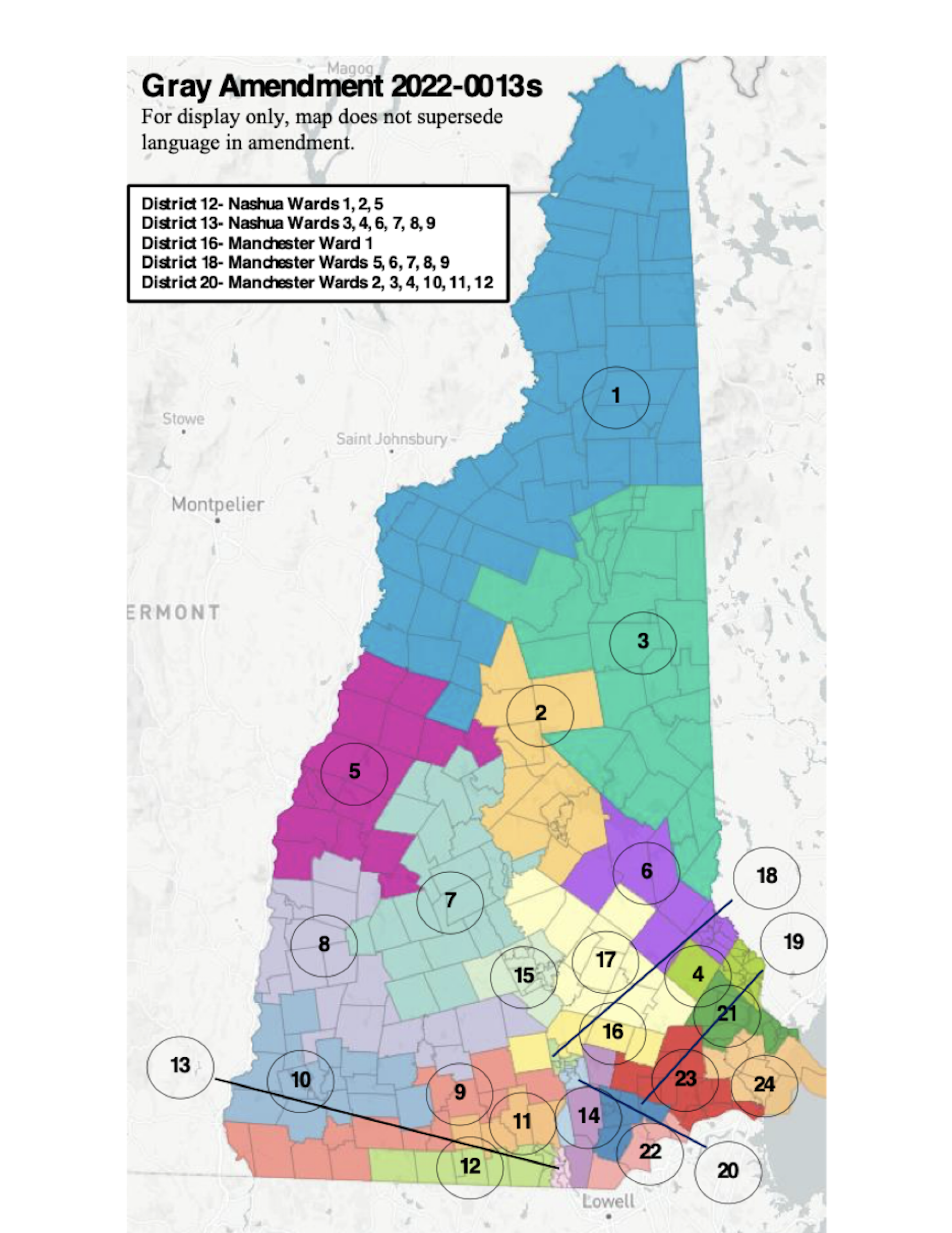
Republican Senators have drawn new Senate districts that are very bad for Cheshire County. If one was drawing districts of common interest, you would start with their county and then school district affiliation and then commerce. Only partisan mapping would align towns by political party sentiment, which is the big take-away from the proposal prepared by the Committee Chairman Sen. Jim Gray, Republican from Rochester.
Cheshire County’s 23 towns are distributed over 4 different Senate districts. The most towns remain in Senate District 10, which includes Keene and Swanzey and 12 other Cheshire County towns: Alstead, Chesterfield, Dublin, Hancock, Harrisville, Marlborough, Nelson, Peterborough, Roxbury, Sullivan, Surry, Walpole, and Westmoreland. Then to reduce Democratic votes in other Senate districts, it adds Hancock and Peterborough from Hillsborough County, which is just the beginning of slicing narrow bands of tagentially connected towns snaking across to Bedford and Nashua to preserve Senate seats held currently by Republican Senators.
Senate District 9 in 2010 crossed county boundaries adding Troy, Fitzwilliam and Richmond to a District represented by a Bedford Republican. All three towns are part of the Monadnock school district centered around Swanzey. To make District 9 territory completely ridiculous, the Republican map adds Winchester and Hinsdale, two towns much more clearly aligned with Keene and Swanzey than with Bedford. The district would be 73 miles wide and take 97 minutes to travel.
Rindge, much more closely aligned with Peterborough, is split off into a district represented by a Nashua Republican in District 12. And Stoddard and Marlow are part of District 8, which now adds Charlestown and Dunbarton, crossing 4 counties, over 60 miles, taking 90 minutes to travel.
This is Gerrymandering, “the practice of setting boundaries of electoral districts to favor specific political interests within legislative bodies, often resulting in districts with convoluted, winding boundaries rather than compact areas.” (Google)
Two political parties need to come together and develop one Senate Redistricting map, the way a non-partisan commission might have had that Democratic proposal been signed into law by Governor Sununu. That map should embrace the principle of compact areas defined by county boundaries, and common interests, like commerce and school relationships, to provide for the most representative government.
You also can convey your opinion to the Senate Election Law Committee at http://www.gencourt.state.nh.us/Senate/committees/committee_details.aspx?cc=1421 Your input is most timely the week of Jan. 10th. The hearing is January 10th at 1 pm in the State House, Representatives Hall.
Jay Kahn


